GTA 6 Map: Leonida, Vice City and Confirmed Locations
The GTA 6 map covers the fictional US state of Leonida, anchored by Vice City and including Port Gellhorn, Mount Kalaga, Leonida Keys, Ambrosia and Grassrivers.
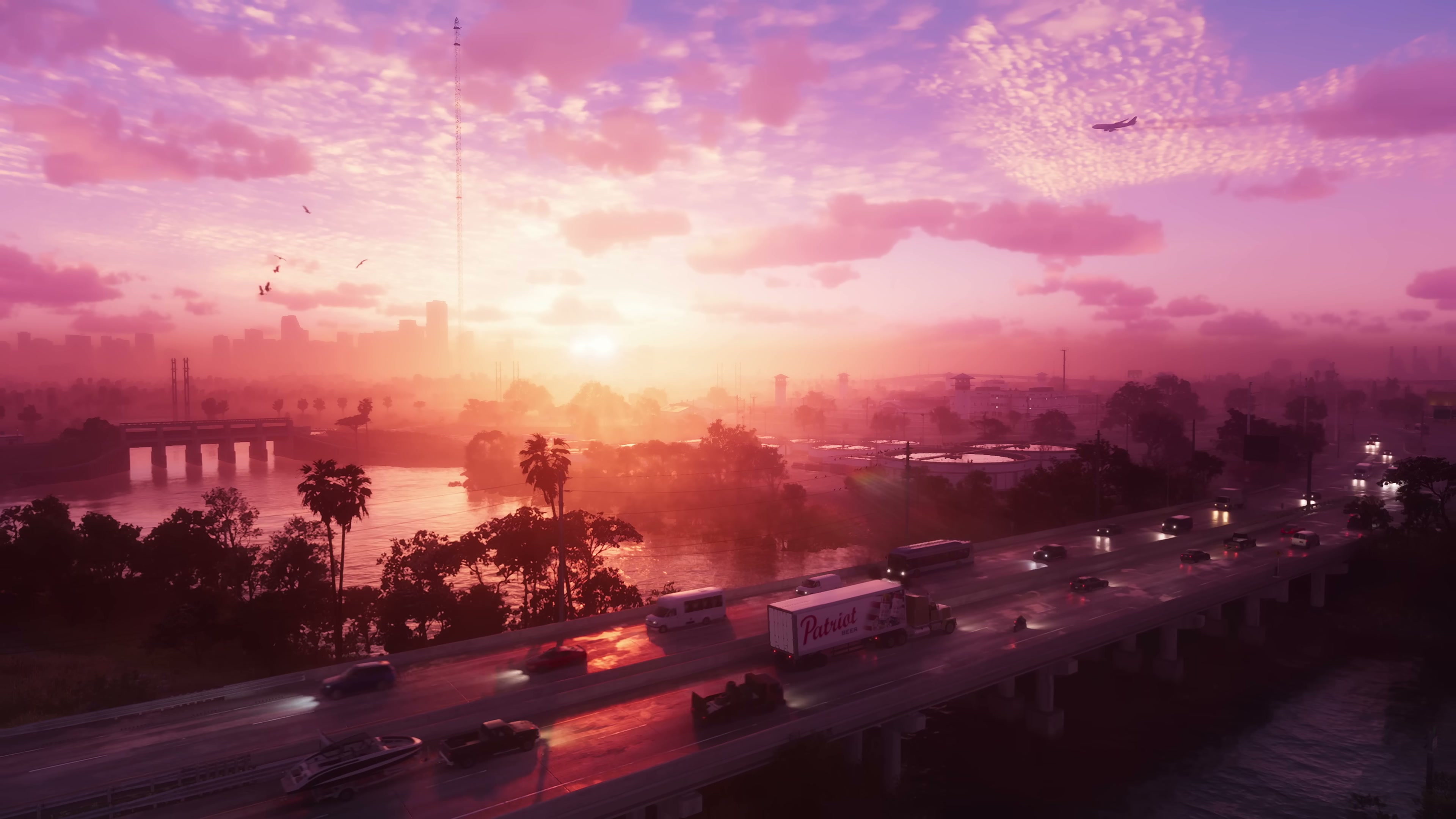
Trailer 1 opens with an aerial sweep over a Leonida expressway at sunset.
Grand Theft Auto VI Trailer 1 · timestamp 0:02 · © Rockstar Games / Take-Two Interactive · Reproduced for editorial commentary under fair use. Retrieved May 21, 2026.
GTA 6 Map: Leonida, Vice City and Confirmed Locations
The GTA 6 map depicts the fictional US state of Leonida, a stand-in for present-day Florida. Vice City sits at its center as the franchise’s reimagined Miami, joined by smaller towns, beaches, swamps and inland regions glimpsed across two trailers. Rockstar has not published a full map render or a size figure, so confirmed geography is currently limited to the named locations shown on screen.
The state of Leonida
Leonida is the in-game name for the broader region that contains Vice City. The state was first identified in Trailer 1 in December 2023 and reinforced in Rockstar’s own product copy for the game. Its geography mirrors Florida: a long coastal urban strip, an inland mix of farmland and small towns, a wetland zone modeled on the Everglades and an island chain extending south from the peninsula. Trailer 2, released in May 2025, broadened the confirmed locations and showed both daytime aerials and ground-level vignettes outside Vice City proper.
Vice City: the urban core
Vice City returns as the franchise’s reimagined Miami, last visited as the standalone setting of 2002’s Grand Theft Auto: Vice City. Trailers 1 and 2 show neon-lit Art Deco hotels, an Ocean Drive-style nightlife strip, rooftop pools, a downtown skyline, multiple expressways and a busy harbor district. Signage in Trailer 1 references neighborhoods including Kelly County, VCI Airport, Catalan Boulevard, the Stockyard and Downtown. Trailer 2 added named venues such as a “Nine” nightclub set in Vice City.
Confirmed regions outside Vice City
Beyond the city proper, Trailers 1 and 2 showed and named several additional regions of Leonida. Each entry below corresponds to footage or on-screen signage in one or both trailers.
| Location | Type | First confirmed |
|---|---|---|
| Vice City | Coastal metropolis | Trailer 1 |
| Leonida Keys | Island chain and causeway | Trailer 1 |
| Port Gellhorn | Coastal port town | Trailer 2 |
| Mount Kalaga | Inland mountain and park area | Trailer 2 |
| Ambrosia | Rural inland town | Trailer 2 |
| Grassrivers | Everglades-style wetlands | Trailer 2 |
The Leonida Keys appear in Trailer 1 as a long bridged causeway over shallow turquoise water with a seaplane flying overhead. The remaining regions outside Vice City were primarily introduced in Trailer 2, which spent its first act touring smaller settlements, swamps and rural Leonida before returning to the city.
How big is the GTA 6 map?
Rockstar has not announced an official size for the GTA 6 map, and Take-Two has not provided figures in any investor materials. Coverage and fan analysis based on trailer footage has speculated the playable area is larger than GTA V’s combined Los Santos and Blaine County, but no official square-mile or square-kilometer comparison exists. Map size estimates that circulate in fan communities should be treated as speculation until Rockstar publishes a render or in-game scale reference.
For context, GTA V’s San Andreas — covering Los Santos and Blaine County — is generally cited at roughly 49 square miles in third-party reference works. GTA 6 will need to be measured against that figure only after the map is released or officially shown in full.
How Leonida compares to past GTA settings
Like San Andreas in GTA V and Liberty City in GTA IV, Leonida is a single contiguous region built around one anchor city. The difference is that Leonida explicitly fictionalizes an entire state rather than a metropolitan area: Vice City returns as a city inside that state rather than as the only location. Structurally that puts GTA 6 closer to GTA V — one major city plus surrounding rural, mountain and coastal land — than to the city-centric maps of GTA IV or the 2002 Vice City.
What has not been confirmed
Several map-related details often discussed in fan coverage remain unconfirmed by Rockstar:
- The total playable square mileage or square kilometers
- Which interiors are fully explorable versus instanced
- Any map-expansion or post-launch DLC plans
- The map and structure of any GTA Online successor
- Whether neighboring states or other cities outside Leonida appear
Additional trailers, preview events and Newswire updates ahead of launch are the most likely sources for more concrete map information. Until those land, the locations table above represents what has actually been shown.
Gallery
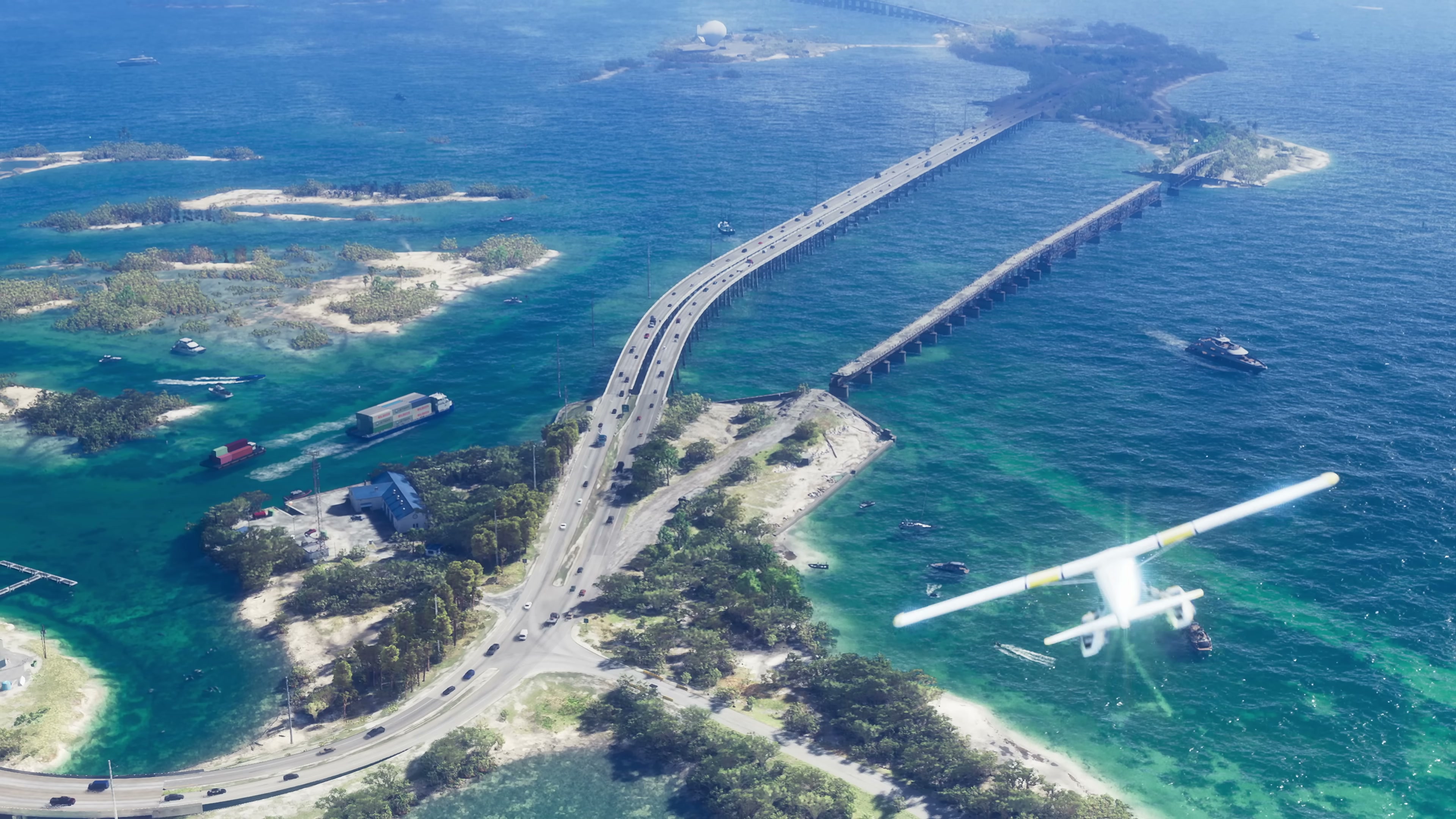
The Leonida Keys causeway as shown in Trailer 1.
Grand Theft Auto VI Trailer 1 · timestamp 0:35 · © Rockstar Games / Take-Two Interactive · Reproduced for editorial commentary under fair use. Retrieved May 21, 2026.
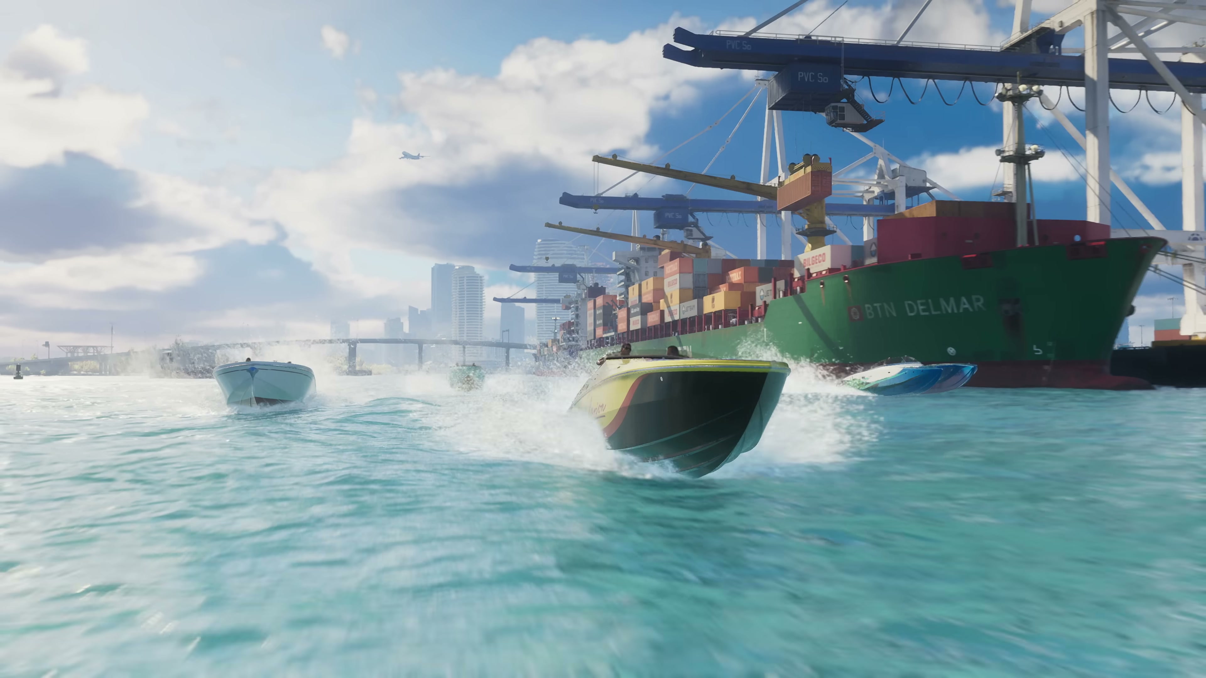
A working harbor district with cargo cranes and freighters in Vice City.
Grand Theft Auto VI Trailer 1 · timestamp 0:23 · © Rockstar Games / Take-Two Interactive · Reproduced for editorial commentary under fair use. Retrieved May 21, 2026.
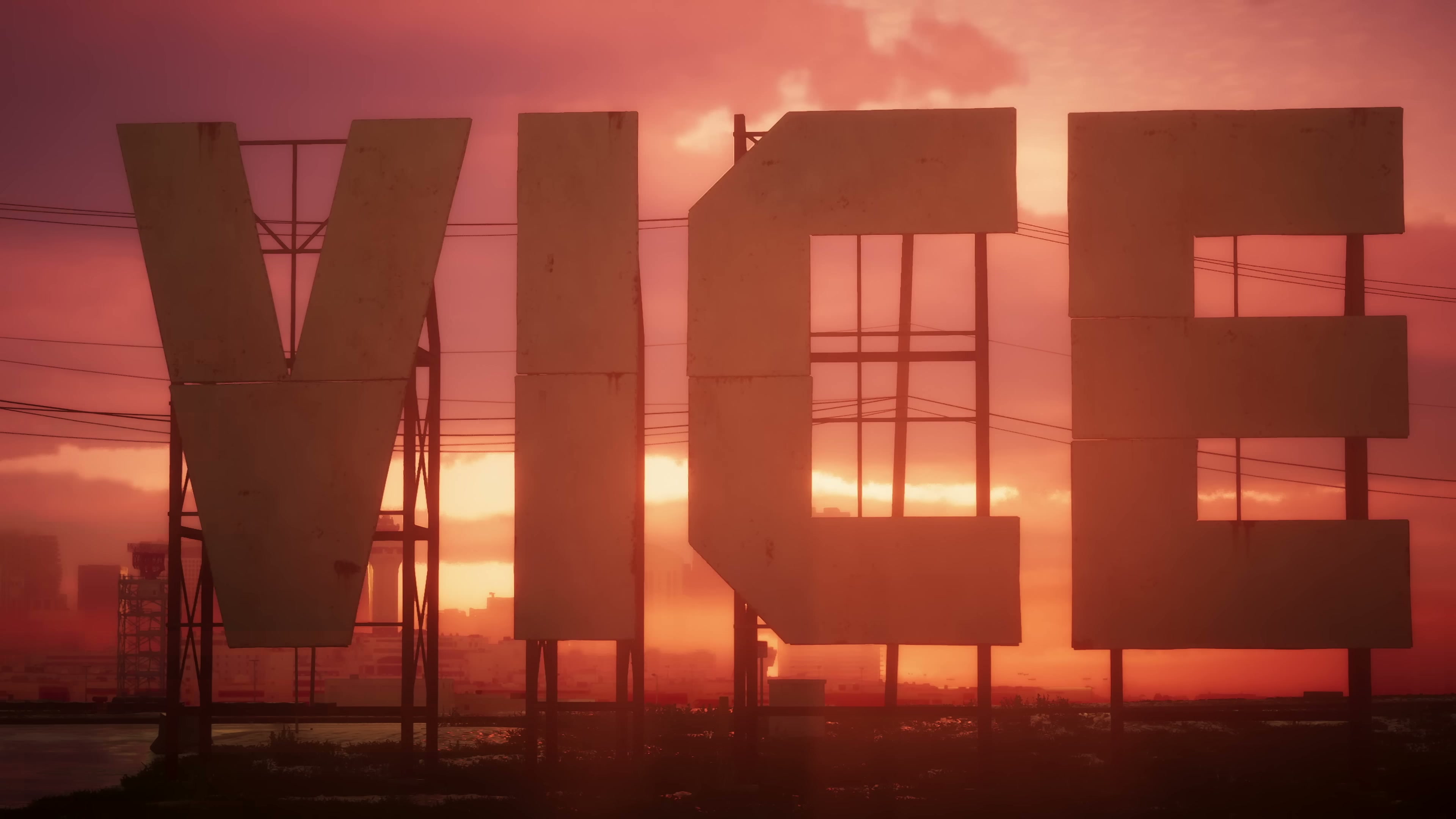
Vice City signage at sunset, glimpsed late in Trailer 1.
Grand Theft Auto VI Trailer 1 · timestamp 0:39 · © Rockstar Games / Take-Two Interactive · Reproduced for editorial commentary under fair use. Retrieved May 21, 2026.
Sources
- Grand Theft Auto VI Trailer 1 (December 4, 2023) (retrieved May 21, 2026)
- Grand Theft Auto VI Trailer 2 (May 6, 2025) (retrieved May 21, 2026)
- Grand Theft Auto VI — Rockstar Games (retrieved May 21, 2026)
- Grand Theft Auto VI — Wikipedia (retrieved May 21, 2026)